


 |
コンビニ 找找超商 Combini (コンビニ) means convenience store franchise chain in Japan. The local convenience store is like a small supermarket, stocked with a wide array of prepared foods and snacks, beverages, magazines, and daily necessities. Most convenience stores are open 24 hours everyday of the year. This Augmented Reality application for iPhone and iPod Touch will help you find the nearest Combinis from your position in Tokyo. Augmented Reality functionality enables you to see the nearest Combinis with iPhone's camera live view. Elements located at a distance less than 1km (0,621miles) only will be displayed. - iPhone vertical position: 360-degree view of all Combinis nearby your location, updated in real time as you walk in the streets. - iPhone horizontal position: List of all nearest Combinis. When a station is selected, a red arrow (compass) is displayed to show the direction and the distance to that point. This application does not require a network connection to operate. Combini (コンビニ) means convenience store franchise chain in Japan. 在日本東京逛街時,若要尋找便利商店,則可打開Combini (コンビニ),結合擴增實境,它會即時的指引大家到達最新的便利超商。(日本大部份的超商也是24小時營業),只有在0.621(1公里)英哩的商店才會出現在螢幕上。 當你決定要到某間超商時,程式會結合iPhone或iPad的鏡頭的鏡頭在螢幕上作360度的指引(會出現紅色箭頭),因為是利用衛星導航,不需要連線功能 |
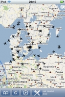 |
Plane Finder 航班導航員 Real time air traffic radar maps on the iPhone and iPod touch! ** See major events such as the effect of the Iceland Volcano Ash Cloud Live or simply watch friends and family fly out ** Now includes improved Europe, US and Australia. (See notes below on coverage). Plane Finder is a amazing app for anyone interested in aviation, planes, flights or air traffic control. It's also great if you just want to know what is up there or if you want to see your friends and family in the air? Plane Finder provides a near real time "virtual radar" showing what is in the sky plus details such as altitude, speed, plane type etc. It's very addictive because there is so much flight movement in the sky. Plane Finder provides real time information on planes and flights in the UK, Ireland, Europe, Australia, Southern Scandinavia and increasingly in the US. It’s easy to use and is fully integrated into Google Maps. Plane Finder also includes flight route information and the airline details. It’s also easy to switch between map views, satellite view and information; it even pulls in photos of the planes. Plane Finder works by picking up ADS-B plane feeds used by all commercial planes to transmit their name, position, destination and lots more. This technology is actually faster than radar and is used in some places for air traffic control and navigation. It’s fascinating and great fun to see what’s going on! Check out the free version (Updates 4x daily) or look at our planefinder.net coverage map for the latest data for your region. 擴增實境應用,藉由讀取資料庫(每台飛機裝有ADS-B),讓我們可以真實知道目前空中航班路線,這個功能在查詢航班時非常有用。 如同火車會有鐵道迷,這軟體適合對飛行、飛機、航班有興趣的飛機迷使用。 可以讓你知道某一航班的狀況、提供真實的虛擬雷達,可以知道某一航班飛機現在的經緯度、飛行速度、飛機型號,就如同你真的是塔台管制人員! 目前支援英國、伊朗、歐洲、澳洲、南斯堪的那維亞、及美國航班。非常簡單上手、並結合Google地圖;可切換成地圖模式、衛星模式及資訊模式。 目前讀取到的資料庫有 英國、愛爾蘭、南斯堪的那維亞、荷蘭、美國-華盛頓、鳳凰城、丹佛、羅德島、北美的溫哥華、東安大略/北紐約和紐約、澳洲、義大利北部、法國南部、捷克共和國、瑞士、德班等。 |